At a glance
Plan Fushimi as two distinct outings: Fushimi Inari Taisha and, if time permits, the canal and sake district farther south. Reach the shrine beside JR Inari Station or from Keihan Fushimi-inari Station. Choose a lower-precinct visit or a longer mountain walk before starting. For the sake district, use its own station and walking map rather than assuming the brewery streets are immediately behind the famous torii gates.
Fushimi Inari and the sake district are different parts of the day
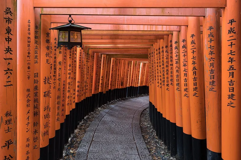
The name Fushimi can make two visitor areas sound like one continuous attraction. Fushimi Inari Taisha is the shrine associated with the vermilion gates and Mount Inari. The historic brewery and canal neighbourhood lies farther south, around places including Chushojima, the Gekkeikan Okura Sake Museum and the Otesuji shopping area. Treat the connection as a transfer, not as a few extra streets automatically included in your shrine visit.
For a first visit, choose a lower shrine outing followed by the canal district, or give the shrine mountain a larger share of the day and keep the brewery area for another occasion. The suggested allocations are editorial allowances: they do not guarantee a museum slot, a train connection or a clear walking route. Your actual transport, fitness and the current visitor arrangements determine what fits.
| Version | Main commitment | What to leave out |
|---|---|---|
| Shorter shrine visit | Lower precincts and a return through the gate area | A full mountain circuit |
| Shrine and canals | Lower shrine visit, transfer, one brewery-area visit | Several tastings or an unplanned summit walk |
| Longer shrine walk | A route chosen from the shrine’s actual mountain map | A time-sensitive museum booking afterward |
| Canal district only | Otesuji area, canal streets and selected cultural visit | The assumption that the torii shrine is next door |
Use the right station for Fushimi Inari Taisha
The shrine’s access page places it immediately beside Inari Station on the JR Nara Line. It also identifies Keihan Fushimi-inari Station as another approach, with an approximate five-minute walk east. These are two different stations and operators. Save the exact station name and the return route; a generic search for Fushimi station can lead to a different part of the district.
Choose the connection that makes sense from your accommodation. If you are already using the Keihan corridor, its station may suit the day; from Kyoto Station, investigate the JR Nara Line service that actually stops at Inari. Confirm the stopping pattern of the train you board instead of assuming every departure on the line serves the same stations.
The shrine recommends public transport because nearby parking becomes crowded. That is another reason to make the station approach part of the plan rather than arriving by car without arrangements. After getting off, establish where you will return before joining the busiest pedestrian flow. Travellers who are building a wider Japan trip can keep our Tokyo travel guides as a separate city plan; Tokyo is not an add-on to this Kyoto afternoon.
Begin with the lower precincts before choosing a mountain route
Use the shrine’s official map to identify Romon, Honden, Senbon Torii and Okusha Hohaisho. These named points help distinguish the lower visit from the longer routes climbing through Inariyama. Spend time with the shrine itself before treating the gates as a photographic tunnel. Fushimi Inari is an active place of worship, and the whole mountain precinct has religious meaning.
The shrine dates its establishment to 711 and describes Inariyama as a sacred mountain 233 metres high. That elevation is not the amount of ascent on every possible visitor route. Decide how far you intend to go using the actual map and local signs. A shorter out-and-back visit through the lower gate area is a legitimate choice; reaching the summit is not required to appreciate the shrine.
Allow room to stop without blocking the paths. When you need to check the map or take a photograph, find a suitable space and let worshippers and other visitors pass. An early start may fit your schedule, but this guide does not promise that a particular hour produces an empty shrine or a crowd-free stretch of gates.
How to choose between the shorter visit and a longer climb
If your main aim is the lower shrine and torii atmosphere, keep the outing limited and return before fatigue changes the rest of the day. Make a turnaround decision in advance, then adjust it to the actual conditions. Do not move the goal farther uphill simply because the next gate corridor appears close. Every additional section also requires a return.
For a longer mountain route, read the official map and follow the signs at junctions. Carry water and choose footwear for the surface and conditions, particularly in rain or heat. A route containing many steps is a different commitment from a short visit to the entrance area. Keep the rest of the day flexible so that you do not hurry the descent to make a museum booking.
If stairs, gradients or walking distance affect your visit, investigate the precise area you want to reach. This guide has not audited a continuous accessible route through the gates or up the mountain. Choosing the lower precincts can reduce the walking commitment, but it does not establish that every approach, facility or surface will suit your needs.
Respect the shrine’s specific visitor requests
The shrine publishes rules intended to protect worship and the grounds. Relevant points for this visit include keeping narrow paths clear while photographing, staying out of restricted areas and using the designated rest areas for food and drink. Do not turn a walking snack or a long photo setup into an obstruction at a religious site.
Follow the signs governing photography at the place where you are standing. Permission to take a personal photograph in one area does not extend to restricted buildings, commercial shoots or drone use. Keep your group together without spreading across the whole path, and give others space to continue even when you are waiting for a particular view.
If you need a substantial meal, plan it outside the active shrine walk. This creates a natural break before deciding whether the canal district still fits. You can finish the shrine visit and return to the city without adding a second destination. The value of the day comes from giving the place attention, rather than reaching a certain number of attractions.
Transfer to the brewery and canal neighbourhood deliberately
The official Kyoto tourism itinerary for Fushimi treats the sake streets and canal landscape as an area to explore in their own right. Gekkeikan’s local map names the Okura Sake Museum, Choken-ji, Otesuji, the canal frontage and other neighbourhood stops. Use that map to build a short connected walk rather than jumping between a list of breweries across a wider area.
Keihan’s Fushimi area map identifies Chushojima and Fushimi-momoyama stations in relation to the brewery streets. Choose one as your arrival or departure point according to the actual route you want, and check the train connection from Fushimi-inari. Do not infer a precise transfer duration from the distance between map pins; waiting and the selected service also affect it.
A manageable outline is to arrive at the canal side, visit one cultural stop, walk toward the shopping streets and finish near a station that serves your return. The sequence is a planning suggestion, not a personally measured route. If you want to include a seasonal canal boat, investigate its own operation and booking conditions before building the rest of the walk around it.
Give the Gekkeikan museum its own booking and payment check
The Gekkeikan Okura Sake Museum explains the company and Fushimi’s brewing culture. It is a more focused choice than entering several businesses merely because they appear on a sake map. Consult the museum’s current visitor information for the difference between a general visit and any guided experience, then book the format you actually want.
At the research check, the operator’s Japanese website announced cashless operation from 1 July 2026 and listed several special changes to opening hours for October and November. That makes older advice to arrive with cash or rely on a standard daily schedule unreliable. Bring a supported payment method and confirm the arrangements for your particular date. This guide deliberately does not invent a universal admission price or a guaranteed tasting package.
Keep tasting optional. Visitors who do not drink can focus on the displays, the canal setting and the neighbourhood walk. Check the applicable visitor and age rules if travelling with children. If you will drive later, choose a non-drinking visit rather than treating a small sample as an exception to the transport plan.
Make the afternoon route about streets and water, not just alcohol
The canal and brewery buildings provide context for the district even without a tasting. On the operator’s map, identify the museum area, Choken-ji and the public route toward Otesuji before starting. Pick a few named points and use the connecting streets between them. This gives the afternoon a shape while leaving room to stop when a detail interests you.
Use the shopping area for a meal or refreshments according to what is actually open. Read menus and check ordering arrangements rather than assuming every establishment serves the same sake-focused experience. A museum slot can be the fixed commitment; the rest of the afternoon should fit around it with an allowance for sitting down.
If rain makes the longer outdoor route unpleasant, shorten the canal walk and keep a confirmed museum visit. If the museum is unavailable, do not replace it with an unsupported promise of a brewery tour elsewhere. You can still take a smaller neighbourhood walk, or return to central Kyoto and move the canal area to another day.
Avoid combining too many Kyoto districts into this outing
Fushimi sits in the southern part of Kyoto, while several other famous visitor areas belong to different parts of the city. After a longer shrine climb or a proper canal-district visit, adding another major temple area can turn the day into transfers. Choose the additional district on another day when possible, and keep this guide’s scope clear.
If you have only half a day, select the shrine or the brewery neighbourhood. With a full day, a shorter shrine visit plus one southern cultural visit can work when the transport and booking align. With an ambitious mountain walk, remove the fixed afternoon appointment. These choices prevent a museum closing time from deciding how fast you move through a sacred landscape.
For a separate trip built around named historical streets, our Seoul travel guides offer another Asian city option. For a slower walk closer to home, see our Ljubljana old-town route. These are comparisons for future planning, not neighbouring stops that belong in the same Kyoto itinerary.
Frequently asked questions
Which station is closest to Fushimi Inari Taisha?
The shrine’s access page places it beside JR Inari Station on the Nara Line. Keihan Fushimi-inari Station is a separate approach, approximately five minutes’ walk west of the shrine. Check the actual train stopping pattern and save the exact station name.
Do I need to climb to the top of Mount Inari?
No. You can choose a shorter lower-precinct visit using the official map and return when it suits your group. A longer mountain route requires additional time and attention to steps, weather and your return.
Is the Fushimi sake district immediately beside the torii gates?
No. Plan it as a separate area farther south, with its own station and local walking map. Chushojima and Fushimi-momoyama are relevant station names for the brewery area; confirm the connection for your selected route.
Can I rely on cash for the Gekkeikan museum?
The operator announced cashless operation from 1 July 2026. Check its current accepted payment methods and the schedule for your visit, including special opening-hour changes. This guide gives no unverified admission or tasting price.
Sources and checks
- Fushimi Inari Taisha — accessChecked: 8 October 2026
- Fushimi Inari Taisha — precinct mapChecked: 8 October 2026
- Fushimi Inari Taisha — visitor requestsChecked: 8 October 2026
- Kyoto Tourism — Fushimi areaChecked: 8 October 2026
- Gekkeikan — museum visitor informationChecked: 8 October 2026
- Gekkeikan — local Fushimi mapChecked: 8 October 2026
- Keihan — Fushimi area mapChecked: 8 October 2026
Itineraries are editorial suggestions for independent visits. Check current prices, opening hours and trail conditions with official providers.